Sunday, June 16, 2013

Highpoint #25: New Hampshire


At the Highest Point in New Hampshire!


Finishing the highpoint in Vermont just after sunset gave me precious little time to drive into New Hampshire and catch some sleep.  I managed only a few winks too, before the sun started to peak out from the sky early the next morning.  Well, there was no time to waste given my packed weekend, so I was up and at it. 

My Poison of Choice for the Day

My route of choice was the Ammonoosuc Ravine Trail.  It is on the west side of Mt. Washington with the trailhead conveniently located just down the road from the Cog Railway Station.  Yes, one can simply take a train to the top of the mountain, or even drive up along the auto road on the east side, but there is nothing sporting about that.  I wanted in on one of the best hikes in America instead.  Now, supposedly you can just start hiking from the secondary hiker lot just before the railway station, but I failed to see where the uphill path connected to the ravine trail.  I decided to just park down the road, instead, at the main trailhead and hike up from there. 

Sign at the Start of the Hike

Official Start


The route is 4.5 miles to the summit, passing the Lake of the Clouds hut along the way after 3.1 miles, prior to joining up with the Appalachian Trail for the remainder of the distance.  In total, there is 3800 feet of elevation gain along this route.  I was in for a treat. 

In truth, other than those statistics, I really wasn’t sure how the route would play out.  The trail is a “summer” route, but it really wasn’t quite summer yet.  I was worried that there might be a lot of snowmelt causing the river to be high.  I also wasn’t sure what the conditions were like on the upper mountain.  Would I need crampons?  Would the weather at the summit be unbearably windy and cold, as it notoriously can be?  I tried to bring a mix of gear, just in case any of these conditions would present themselves.  I brought rugged soft-shell pants for the scrambling, super gaiters in case the water level was high, a rain suit should the weather change for the worse, and I even packed a compressed down parka in case I encountered freezing temperatures at the top.  Sounds crazy, but those were exactly the conditions the weekend before. 

The hiking started off quite gently.  It was almost flat really, following the Ammonoosuc river from one side or the other.  

First Encounter with the Ammonoosuc!

More Ammonoosuc, with Rustic Bridge


Eventually, I made my way up to a pool of water at the foot of a large waterfall. 

Gem Pool

This is where the hike got decidedly interesting.  For the next couple of miles, it would be nothing but steep scrambling, climbing alongside this waterfall and higher waterfalls leading all the way up to the Lake of the Clouds Hut. 

The Steep Scrambling Begins!
Great Waterfall Action


A Completely Unnecessary Ladder!

The nice thing about a steep route, is that you gain elevation quite quickly and the view really starts to open up, rewarding you for all of the hard work.

First of Many Great Views!


Plenty of Waterfalls on this Route!


Continuing along, I soon found myself in the alpine zone.  There was a sign marking the boundary, admonishing hikers to try to stay on the rocks as much as possible as any plant life is sensitive and vulnerable. 

Alpine Zone!

If only it were simple as that!  No, as soon as I entered the alpine zone, the trail conditions took a turn for the worse.  Now I was encountering ice floes.  The character of the ice was pretty tough too, which explains why they had yet to melt by the beginning of June.  They were not everywhere, but they were present enough that they became a consideration on how to proceed. 

First of Several Ice Floes

I opted to not bring crampons, so I had to be a tad more careful in these parts.  In all, they were pretty negotiable except for one place where it was quite dangerous.  Indeed, in one section there was a very large slab of ice where one had to cross the water just past the head of a giant waterfall.  I was left with the awkward choice of climbing onto and over this slab of ice and being very careful not to slip, lest I continue all the way down the waterfall and into the ravine.  I spent a good 15 minutes deliberating what to do in that section, before finally sequencing a set of moves that put me safely on the other side.  Yikes!  Definitely bring crampons, if you are trying this early season – just in case!

Another issue with the ice and occasional snow, was route finding.  Somehow I managed to lose the trail up high.  I found myself making a beeline for the Lake of the Clouds Hut working my way up a boulder field.  It definitely felt wrong, but I wasn’t exactly lost with the hut in plain view, so I just kept going.  I pulled myself up and over the ridge, and popped into the hut to see what was going on. 

First Glimpse of Lake of the Clouds Hut, Completely Off Trail

Sadly, no one had any time to talk to me.  It was the first day of the season for them, and the staff was working furiously to get the hut clean and in good working order.  As such, I really didn’t stay long, but I managed to fill up the water bladder in my daypack, so all was good. 


Detail of Sign at Entrance to the Hut

View from Above the Hut

Surprisingly, I was still a good 1.4 miles from the summit.  It looked so close, but there was still quite a bit of meandering left, moving from one rock cairn to the next.  I was now following the Appalachian Trail at this point, so it was quite a bit easier.  I enjoyed the gentler, if not exactly easier, hiking and took in the great panoramic views.  It was still early morning, so there was hardly anyone out here, though I did spot 2 hikers ahead of me that must have come up along one of the other routes. 

Another View of the Hut

The "Lake of the Clouds"


At one point, there was a sign telling me to “stop” and to be careful about proceeding, as some of the worst weather in the world has been seen at the summit.  No joke!  Winds have gusted all the way to 231 mph at the summit.  That’s not a typo.  The conditions can be dangerously unpredictable, changing drastically in mere hours.  Hence, the reason I brought all of my extra gear.  Luckily, I wouldn’t need any of it though.  I was in for a great viewing window.

Stop!  In the Name of Love?

Well, it wasn’t long after seeing the antenna at the top come into view, until I found myself at the foot of the stairs for the Tip-Top House, and then the summit itself!  

First View of the Antenna at the Summit


Tip-Top House, Adjacent to the Summit


I arrived at the same time as a small group of hikers who took the Jewell trail.  They obliged to take a photo of me at the summit sign, before returning the favor.  I also managed to get a photo of the summit marker as well as a USGS directional marker located in the rock pile nearby. 

Summit Marker

USGS Directional Marker, Nearby


I managed to work my way over to the famous observation tower.  It was kind of weird being on the other side of the live camera in front of the “X” that is visible on nice days, and completely invisible on the not-so-nice days.  Again, this was a great day, so I had a perfect view all around. 

Note the "X" and the Exceptionally Good Weather

I made my way farther down to a lookout for the peaks that make up the Presidential Traverse as well.  Another day, another challenge. 

Detail of the Presidential Peaks

After taking in all the views, I noticed a considerable influx of tourists that were arriving by car and train.  I decided to head into the gift shop and the adjacent cafeteria to play tourist for a while.  I signed the tourist register, bought a mug, and loaded up a cafeteria tray with plenty of food.  Unfortunately, the food was not very good, but after hiking all morning it worked well enough.  If I arrived by car or train, I would have been sorely disappointed, however. 

The Gatorade was Okay...

I hung out for a bit in the cafeteria, just resting up.  It was a welcome respite after all of my hiking that morning and the night before, not to mention the driving.  Looking at the time though, I was worried about my ability to hike down the mountain in a timely manner, given some of the sketchier spots, and still drive to upstate Maine to check in at the campground where I had a reservation before the cutoff time. 

I decided to take the easy way out and join the tourists on the train ride down instead.  A mere $45, would buy me back a few hours of time, so it made sense.  Plus, I kind of wanted to get the “other” experience, too.  I already did all of the hard work and earned the summit; I might as well rest up a little bit before trying my hand at Mt. Katahdin. 

Tourists Lining Up to Take the Train Down

I lined up at the next boarding call, all the way in the back as a stand-by passenger, and easily found a seat to myself next to one of the open windows.  The ride down was narrated in detail, so it definitely added to the experience.  We had a bit of a hiccup half way down though, so we had to go back up, trip one of the switches and come back down a second time before finally pulling in at the Cog Railway station. 

Detail of the Train at the Base of the Mountain

So, I managed to save a little less time than I was intending, but I still found myself at the bottom fairly quickly, so all was good.  From the station, I just walked down the road to the main trailhead, got in my car, and continued on to my next highpoint:  Maine. 

All in all, this was a great hike on a formidable mountain.  I definitely want to come back and try my hand at it again from the east side.  I also want to do a winter ascent and maybe even a Presidential Traverse one day.  There are so many possibilities here, making the experience that much richer.  What a great highpoint to mark my halfway point!  Yep, 25 states down!  Yay!


Parting View from the Top!

Sunday, June 9, 2013

Highpoint #24: Vermont


Atop Mt. Mansfield -- Finally!

With summer fast approaching, I was itching to get on the road again.  I strategically waited until the weekend AFTER Memorial day weekend, so I could avoid the traffic and crowds.  My first stop?  Vermont.  I had some unsettled business up there, and I was all too keen to resolve matters. 

See, back in February when I did my highpointing trip for Rhode Island and Massachusetts, I also tried my hand at Vermont.  Yes, February, right after the Nemo storm passed through the area.  There really could not have been more snow on the Mt. Mansfield when I visited then (what was I thinking?).  It ultimately did me in when I approached the final headwall, forcing me to come back another time if I ever wanted to lay claim to the summit.  Well, last Friday was the day!  There wouldn’t be any snowdrifts to swallow me up this time around.  The challenge was on!

I left my place in D.C. first thing in the morning, and I ultimately made it to the Stowe ski resort in upstate Vermont late in the afternoon.  I wanted to take the exact same route that I did in February, so I could see how close I really got to the summit and figure out where I went wrong.  So, for me, that meant taking the Long Trail south and connecting to the Profanity trail, which is a recommended approach in prime winter, when it’s passable anyway. 

Road:  Summer
Road:  Winter


I parked in the small hiker’s lot next to the gate just off the road from the uphill entrance to the ski resort and well before Smuggler’s notch.  The first difference that I noticed was that the gate was open and the road was pristine.  In the winter, that gate is as far as you can get by car as they close the rest of the road until late spring. 

Trailhead:  Winter

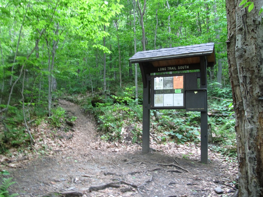
Trailhead:  Summer


After a little bit of a walk, I crossed over the road into the woods at the trailhead for Long Trail South.  From there, it is a 1.7 mile hike all uphill to the Taft Lodge.  In the winter, the route was a very popular one with backcountry skiers and the occasional person on snowshoes, like me.  There are plenty of switchbacks, interrupted by a few stream crossings.  In the snow, there was a very clear, smooth path made by skiers in the prior days.  I was able to snowshoe right along that path with no problem at all.  I, thankfully, had heel lifts on my snowshoes which helped with the elevation gain considerably.  In summer though, the path was definitely very rocky and not so smooth.  There were plenty of tiny obstacles to be negotiated, but it was still a pretty straightforward hike. 

It's Easier to Snowshoe...


...Than it is to Hike!


In the winter, the route went direct to the Taft Lodge!  Evidently, skiers are pretty efficient at getting where they need to go.  In the summer, the path meandered and came back around to it, making for a gentler approach. 

Taft Lodge:  Winter
Taft Lodge:  Summer


On both hikes, I opted for the Profanity Trail to go straight up the mountain with less danger of rockfall and exposure.  Look at the signs though from the two trips!  This really tells you how much snow they get here in the winter!!  The smaller sign underneath the main sign was completely covered by snow; I didn’t know it existed!

Sign for Profanity Trail:  Winter

Sign for Profanity Trail:  Summer


Going up from here was definitely tricky in the winter.  I think most of the skiers just stop at the lodge and either take the moguls down for some good backcountry skiing, or they just wander over to the Chin Clip run at the ski resort and ski down the black diamond route.  Why do I say this?  Because routefinding became quite a bit more difficult after I passed the lodge.  The Profanity Trail is marked with blue blazes, but it seems a little harder to follow, at least initially. 

Profanity Trail, Earlier On


Profanity Trail, Near the End


Last time, I made my own path, and proceeded up the mountain the best I could, but I had enormous difficulty.  Every once in awhile, I would just fall into a snowdrift up to my stomach, and sometimes up to my neck!  These were, I later learned, called “spruce traps”.  They can be kind of dangerous, especially if you are climbing solo.  I eventually had to pull out the ice ax.  With two hands, I plunged it horizontally in front of me, and pulled myself farther up the mountain, again and again.  It was intense.  Ultimately, I reached a spot a bit in front of the headwall that I could not get past.  Everything I tried with my snowshoes, ice ax, grabbing a random spruce branch, or finding an alternative route just failed.  I was stuck!  I eventually had to accept that I was not going to get the summit, and resolved to return another day. 

DEEP Snow!!

To be Continued Another Day!


Well, this time, the story was much better.  The Profanity Trail is MUCH easier to follow when there is no snow.  It also goes a bit to the left of where I was climbing in February.  I clearly was off-route, and when I looked over to it in the summer, I was surprised I could get through any of it at all.  The snow hides a lot!  No, this time the path was narrow and filled with straightforward scrambling.  It did not take long for me to reach the alpine zone. 

Yay!  The Difficult Portion is Over!

From there it is a piece of cake to finish.  Just follow the boarded off trail portion to the true summit.

It's Pretty Easy Going From Here to the Summit!

At the top, the view is incredible.  A 360-degree panoramic field of vision is available to you, allowing for a keen view of Stowe ski valley and points beyond.  I was the last hiker of the day there, so I had the whole place to myself.  It was so beautiful.  I took my usual photos. 

View of Stowe from the Summit
There was a USGS marker to denote the summit, but it looks like it was kind of beat up.   I eventually decided to head down, before the sun beat me to it. 

Vanity Shot at Summit USGS Marker


Detail of Beat Up USGS Marker at Summit


I made great time back to the Taft Lodge, but now it was starting to get dusk.  I was like, “oh I am pretty close to the car now; Just smooth sailing from here.”  Ugh.  Sure enough, I messed up on one of the stream crossings, and kept following the stream instead of the trail.  Rapid current, wet rocks, and darkness made for a treacherous combination.  I kept descending, trying to lose elevation, but there was no sign of the Long Trail or the highway that I walked in on.  Luckily I had a headlamp and GPS, but still this was quickly becoming bad by the minute.  I tried wandering away from the ravine, but it was dense and not yielding me anything useful.  After a good half hour of this, I finally stumbled onto a clearing next to the rapid.  Sure enough, it put me right back on the Long Trail.  I couldn’t believe it!! I signed out at the trailhead, and walked back to my car. 

It’s funny because I also had trouble following the trail back in February on the way down.  I got lost in the moguls and eventually made my way over to Chin Clip and walked down the ski run to the Stowe parking lot.  I am sure ski patrol loved the idea of a guy emerging from the woods onto one of their ski runs holding an ice ax in his hands.  Oh well, so it goes in this highpointing business.  The skiers could not have been friendlier though, with one going so far as to cheer me on.  

View of Mt. Mansfield, by way of Chin Clip, from Stowe Ski Resort Parking Lot

In truth, this mountain was just not going to give up its highpoint easily to me.  I never had so many problems before with such a seemingly simple hike.  Oh well, it’s off the list, and I could not be happier.  Honestly though, this is a beautiful hike anytime of the year.  I am glad it turned me on to a pretty cool ski resort too. 

Are there other ways up the mountain?  Yes, several of varying difficulty.  There is even an auto road that goes up to the lower summit in the summer, but you still have to hike a nontrivial distance from there to the true highpoint, so it’s not exactly a drive-up.  It also feels like cheating, since it is a private (read: expensive toll road) road up the mountain.  There is also a gondola available at the ski resort, but I am not privy to the details.  Good luck though on any approach; you likely will not be disappointed.  Just be careful coming down.  Complacency can lead to adventure rather quickly. 


Beautiful Parting Shot from the Summit


Sunday, May 5, 2013

Highpoint #23: Tennessee


Vanity Shot at the Highest Point in Tennessee!


Finishing up Kentucky relatively early in the day, I decided to push on to Tennessee to visit its highest point at Clingmans Dome, just outside of Gatlinburg.  The trip was pretty easy going until I wound up in the vicinity of Gatlinburg; then it was nothing but standstill traffic.  Eventually after a half hour of just sitting around (literally), I learned that the roads were being closed for some sort of funeral procession involving firemen.  After that cleared, I proceeded towards Smoky Mountains National Park only to make a grave error.  Instead of taking the “bypass” route, I opted to pass through Gatlinburg itself.  More standstill traffic awaited me!  Apparently it is set up like the Las Vegas strip there, with businesses all up and down both sides of the road, with tourists walking from side to side all along the way.  It might be a tiny tourist trap town, but it took forever to drive through.  I eventually made it though, and found myself within the perimeter of the national park.  For the would-be highpointer, definitely take the bypass!

I followed the main road up through the mountains.  The road is quite windy and goes on for quite a distance, ultimately connecting to Cherokee, NC.  On my visit though, the road was closed at Newfound Gap due to rock fall occurring during the winter.  

Turn-off for Clingmans Dome Road

Luckily, the turnoff for Clingmans Dome occurs just before Newfound Gap when driving in this direction, so the road closure had no effect on my plans.  Of course, the road to Clingmans Dome itself is also closed during the winter, but they had just opened it up a few days before.  So, really I was all set to just enjoy the views and drive to the top. 

Note:  The Road is Seasonally Closed!

It was quite the drive, too!  Just to get to the turn-off for Clingmans Dome, it was 16 miles of mainly switchbacks.  It was so green and inviting.  The park was definitely the kind of place where one would want to do some extended hiking and camping.  It’s not just me either; Smoky Mountains National Park is actually the most visited national park every year out of all the ones we have!  At the turn-off for the dome, it was still another 7 miles to the parking lot!  The road was in fantastic shape though, so I just kept soaking in the beauty. 

Informative Plaque at the Summit Parking Lot

At the parking lot, there was a very large overlook where you could see for a considerable distance.  Mountains abounded in seemingly every direction.  To continue to the summit, it was all on foot from here.  There was a paved trail, one-half mile in length, extending all the way to the summit.  

Final Stretch:  Half-Mile on Foot!

It was all uphill, of course, so they provided benches all along the way for rest stops.  It’s crazy that a 1-mile, round-trip hike would require them, but I guess it makes the trail accessible to everyone that way.

Paved Trail to the Summit

The hike was a very quick jaunt, and surprisingly well-signed.  

Just in Case You get Lost on the 0.5-Mile Stretch!

The superstructure that is Clingmans Dome quickly came into the view.  

First Glimpse of the Summit

I finally made it the dome itself, and proceeded up the smoothed spiral walkway, reminiscent of the Guggenheim, leading to the main lookout deck.  

Up We Go!

From the top of the deck, I had the best view in all of Tennessee, being able to look out for nearly 100 miles in all 360 degrees of viewing directions.  

Half-way Up

The panoramic view was simply gorgeous!  I appreciated it the best I could, but it did start to get a little busy up there.  I kindly had someone take my photo, and decided to head back down to the base of the dome.  I walked all around the base of the dome, but I was unable to find any geological markers commemorating the highpoint.  

View from the Top!

I know the dome itself is man-made, so while going to the top was fun and informative, the true highpoint lied just beneath it somewhere along that mountaintop.  Between my loop of the structure and my attempting to put my foot on top of what looked like the highest point, I felt comfortable in being able to scratch this one off of the list. 

View from the Dome of the True Summit Below

I strolled back down to the parking lot and took another good look out over the distance, before ultimately deciding to head down the mountain for good.  

Equally Impressive Views Can be had from the Parking Lot!

Now the true challenge of the day was before me.  I had left at 4:30am from Washington D.C. and had just visited the highpoints in Kentucky and Tennessee.  It was early evening.  Could I push all the way back to D.C. in the same day?  I decided to go for it.  Believe it or not, I actually made it!  After an unhealthy number of Red Bulls (seriously), I pulled into the garage of my building at 2:30am.  I did the whole trip in a mere 22 hours.  I managed a total of 1160.7 miles of driving all in the same day (defined as a 24-hour period).  That is a new 1-day driving record for me – yay!  To be a good highpointer, it probably helps to have an obsessive personality.  J

Proof of 1-Day Mileage!