Sunday, April 14, 2013

Highpoint #22: Kentucky


Kentucky! 

Well, I was in the mood again for another highpointing trip.  It had been over a month since I last hit the road, and two nearby states were sticking out on the map like a pair of sore thumbs:  Kentucky and Tennessee.  These are the last 2 southern states for me, and I had yet to visit their highpoints.  The highpoint in Kentucky is a drive-up as is the highpoint in Tennessee, most of the year.  The road to the top of Clingman’s Dome in Tennessee just opened up for the season according to the Smoky Mountains National Park website, so this was good of a time, as any.  I opted to do both – IN THE SAME DAY!  Nearly 1200 miles of solo driving, out and back… could it be done? 

I left my place in D.C. at 4:30am to get an early Saturday morning start on I-66 and eventually I-81.  The latter interstate continued interminably towards Tennessee.  It is amazing how big Virginia actually is.  Luckily, the southwestern corner of the state is really gorgeous.  There were mountains everywhere, and the views were beautiful.  I eventually made my way up to Appalachia, VA and took 160 into KY. 

You have to look quickly though, the turnoff to the highpoint of KY is right between the “Virginia Welcomes You” sign and the “Welcome to Kentucky” sign.  I always thought the space between state lines was “no man’s land”, but apparently, here, it is all Kentucky. 

Turnoff to Highpoint is Literally Next to the VA Border

Fortunately, there are road signs in each direction saying “Crossing Black Mtn. / Highest Point in KY”, so there is some indication that you are close to the summit. 

Sign for Black Mountain:  Are those BB Shots?

The turnoff is a road of mixed character.  It was at times muddy, at times paved?, and at the end, graveled. 

Road to the Highpoint

It’s narrow though, so allowing oncoming traffic to pass requires some coordination.  It goes on for longer than I would have guessed, considering that I was already pretty much at elevation.  I passed the FAA Long Range Radar Dome on the way and eventually pulled in behind a school bus parked before the final stretch leading to the summit. 

Sign En Route


FAA Long Range Radar Dome


The school bus belonged to Mountain Alliance, which, I gathered, was some sort of outreach organization getting kids to explore the outdoors.  I walked the final hill to the summit with one of the guides.

Final Stretch to the Summit

Seeing my Washington D.C. license plate, he asked if I really drove all the way in from D.C. for this?  To which I responded with a lame, “yes”.  This will make more sense one day when I go to climb Denali, as these highpoints all fit together.  Individually though, some of them are definitely met with their share of skepticism.  I opted to not further embarrass myself, by not asking him to take a photo of me at the summit.  So it goes.    

The Summit of Black Mountain!

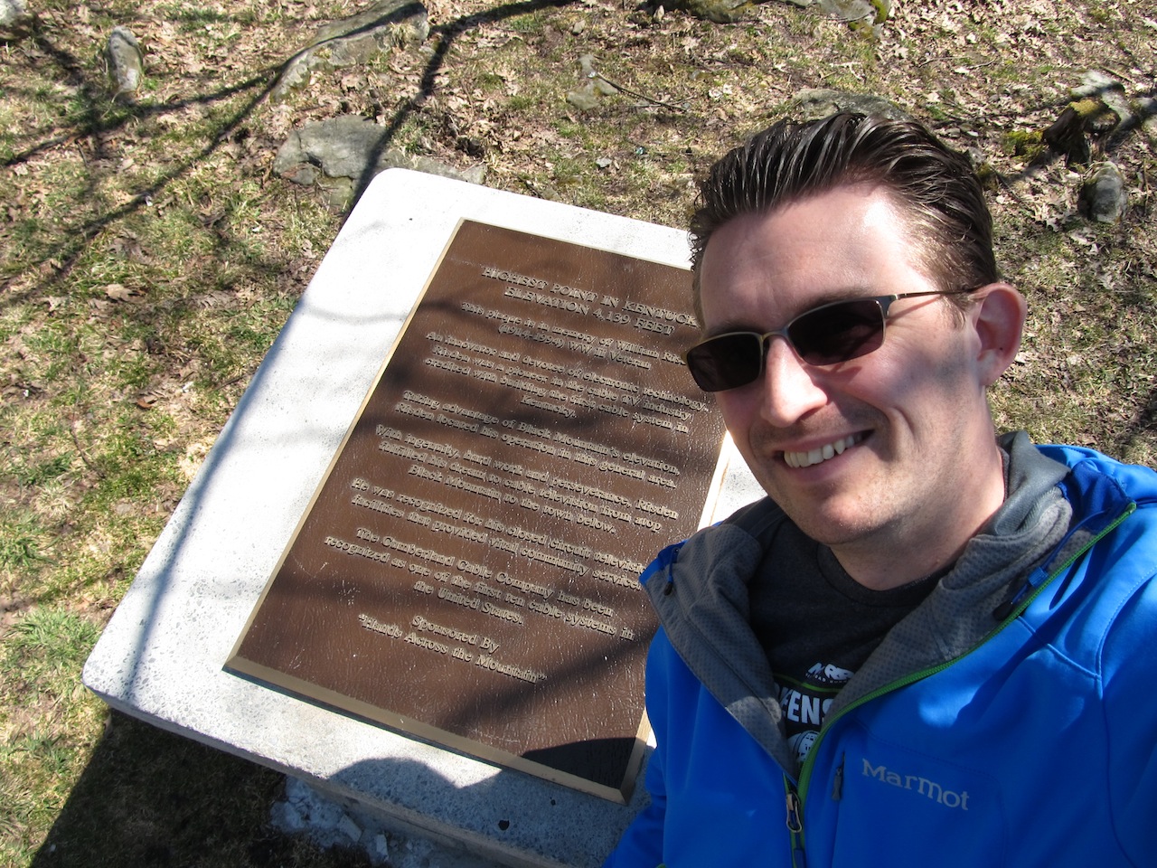
Walking around the summit, there was not a whole lot to see.  While the view by the turnoff was dramatic and extending into the distance, the view from the summit was virtually nonexistent.  Around the summit, there were a few points of interest though.  The obvious one was the actual summit plaque, which marked the highpoint and gave a short history on the area.  

Summit Plaque and Monument 


Vanity Shot in front of Summit Plaque


Additionally, there was a fire tower that was centrally located on the hilltop.  

Fire Tower at Summit


Detail of Fire Tower

Underneath it, I was able to find a USGS marker with the triangle symbol.

USGS Marker Beneath Fire Tower
Strangely, there is some dispute as to whether the highpoint is indeed underneath the fire tower.  This is said because, nearby, there is a large summit rock with another USGS marker.  That marker is the benchmark marker, and it does have a specific elevation recorded on it. 

Summit Rock

USGS Bench Mark with Elevation

The latter marker apparently sets about 6 feet lower than the former marker.  It could be the true highpoint if the mound under the tower is manmade.  I am not sure which is the true highpoint, but I made sure to visit both and take vanity shots just to cover my bases. 

Vanity Shot on Summit Rock
Vanity Shot at Fire Tower

I made a final loop around the summit area and then descended down the hill back to my car.  I drove down to the entrance and parked by the overlook.  This was really the best part.  The view was incredible here!  It was lunchtime, but I didn’t have the forethought to bring my lunch here.  It would have been a great spot to spend some time and soak in the beauty.  Oh well, if I was going to visit the highpoint in Tennessee and make it back home all in the same day, I had better get going…

View from the Overlook! 

Note before you go:  the highpoint is on private property, so a signed waiver agreement is needed either on your person or sent in beforehand.  A current copy of the agreement can be found here:


Sunday, March 10, 2013

Highpoint #21: Massachusetts

Vanity Shot at Summit Sign


After Rhode Island, I headed onward to Vermont and then Massachusetts.  Sadly, there was just too much snow from the Nemo storm for me to count Vermont as my 21st highpoint.  I had to turn around no less than 0.2 miles from the summit, but I did learn a new term:  “spruce traps”.  Sinking my entire height into snowdrift made it impossible to proceed any farther, even with an ice axe!  Yikes!  I wasn’t sure if I should try again the next day by a different route or just push on south to Massachusetts for an easier go at things.  I ended up doing the latter since there was no guarantee of fewer snowdrifts on the other side of the mountain, and, fortunately, everything was much easier by comparison.

I began driving south and arrived in Adams, MA in the middle of the afternoon.  The day was pretty long at this point having hit the trail at Mt. Mansfield by sunrise, knocking out several miles of snowshoeing, and driving from northern Vermont all the way down to Massachusetts.  Honestly, I was starving too.  Before I could go any farther, I stopped and picked up an awful “meatloaf sub” at Angelina’s (a local chain) on the way in, and kept going to the Cheshire Harbor Trailhead. 

7-Mile Hike and It's Almost Dark

I managed to eat half of the sandwich by the time I made it to the trailhead, but I gave up on eating the other half.  Starving doesn’t mean you are willing to eat just any old thing, apparently.  Man, that sandwich was terrible!  By this point, it was around 4:30pm.  I knew I had about 60-90 minutes of daylight left.  The trail is 3.5 miles each way, making for a 7-mile hike.  Obviously, I would not have enough time to hike the whole length and back in the daylight, so I grabbed my headlamp.  I figured that I would just assess the trail conditions for a couple of miles and go from there.  I fully resigned myself to knocking out the highpoint the next morning at dawn and just regarded this as a reconnaissance mission of sorts.

Cheshire Harbor Trailhead

The signs at the start of the trail though gave me some hope.  Apparently, the majority of the Cheshire Harbor Trail is a path used by snowmobiles.  Better yet, the route was temporarily closed to snowmobilers on my visit to prevent damage to the trail surface.  That told me that the snow was not very deep, definitely not “spruce trap” deep, and what snow I would encounter would likely be packed down and smoothed over from prior snowmobiling activity.  And it was!  This was going to be an easy hike!

Easy Snow Hike!

I left the poles and snowshoes in the car, and started off at a very quick pace with nothing to hinder my forward progress.  I made my way up some modest switchbacks, and finally I got my first glimpse of Mt. Greylock.  It was still a bit off in the distance, but the approach seemed clear enough.  I was clearly working my way up to the Appalachian Trail, and then hanging right along a ridgeline to the summit.  The tower at the top was clearly evident at this distance, and, indeed, beyond. 

First View of Mt. Greylock

After a mile, I came across a bit of signage marking the formal turnoff for the Cheshire Harbor Trail.  The path narrowed some, but the character of the trail was still easy.  

One Mile Down, 2.5 to Go!

I thought for sure that I would encounter a few folks on their way down at this point, given the other vehicles I saw in the parking lot, but I never saw anyone. 

Still Relatively Easy Snow Hike

Eventually, the trail met up with the Appalachian Trail.  

A Wintry View of the A.T.

I had the choice to continue along the A.T. farther south or I could just follow the road that passed through this juncture since it presumably would also lead to the top.  (In warmer months, one can actually drive to the summit, but the road is closed during the winter; indeed, the road wasn’t rescheduled to open until May).  

Option 1:  Follow the A.T.  (Yay!)


Option 2:  Follow the Road  (Boo!)


I kept true to the hike and followed the signs for the A.T.  This route saw a bit less traffic, as there was now moderately deep snow and only a set or two of boot prints to follow.  Daylight was holding out, so I pressed onward. 

A Lonely Meadow Along the Way
 
The hiking was still gentle enough, and I quickly found myself in a meadow.  I passed through it, hiked some more and came to the road once again.  So it goes.  

The Road Again with the Sun Setting in the Background

I, again, chose to follow the A.T. signs to continue to the summit rather than follow the road.  Technically, this time the A.T. was more direct than the road, making a beeline for the summit rather than looping around. 

Getting Closer!

Note the A.T. Blaze

I proceeded farther, passed by a radio tower and encountered yet another sign for the summit, hiked a wee bit farther, and finally came into full view of the summit tower.  Yes!  I made it to the top without having to wait until the next day!

First View of the Summit Tower

The tower is huge!  Rising 93 feet into the air, the tower is actually a memorial to honor those from Massachusetts who died in WWI and subsequent conflicts.  This is very similar to the highpoint in New Jersey, which also has a commanding tower in honor of its veterans.  It’s an interesting idea.  Beyond the great views, it makes the place special for an all-together different reason and gives visitors an important place to see.  Well, visitors during the summer anyway; during my visit, the tower was boarded shut.     

Boarded Shut for the Winter!

I posed for a couple of vanity shots, in the foreground of the tower and also by a summit plaque along the tower wall.   
Vanity Shot in Front of the Tower

I was lucky in a way with my very late start, because as I arrived the sun was setting.  This made for some beautiful views!  I was drinking in the beauty.

Sunset View from the Top

After finishing these highpoint duties, I saw my last bit of daylight was about to vanish.  I decided to change modes, turn on the headlamp, and quickly head down.  It was amazing how black it got!  I would not have been able to see much of anything without the headlamp.  

 My Hike Down the Mountain in the DARK! 

Fortunately, I was able to descend in little time at all and drive off into the night all the way back to Washington, D.C.  I managed to arrive home in the middle of the night, making my VT/MA adventure just shy of a complete 24 hours.  Yikes!  Getting this highpoint the hard way was totally worth it though, and Mansfield was a genuine adventure in its own right.  Good times.  

Sunday, February 24, 2013

Highpoint #20: Rhode Island


Roadside Summit Sign


I have to confess that it didn’t take too long after my cross-country road trips, to want to head out on the highway again in search of a few more highpoints.   It’s strange.  The more highpoints that I visit, the more I want to visit new ones.  This time around, instead of focusing on southern states, I wanted to head up into New England to visit a couple of highpoints in a quick turn-around weekend.  I was all set to go, too, when news reports were overtaken with warnings about Nemo and it being the storm of the century.  A quick inspection of the swath of land that contains Rhode Island’s highpoint showed an estimated 3 feet of snow -- yikes!  I dutifully sat out the storm and decided to try for it the following weekend.

Jerimoth Hill Trail
Note the Hours!


My first stop was Rhode Island!  The highpoint is Jerimoth Hill, and it is located just across the border from Connecticut, in the northern portion of the state.  Being named a “hill” and rising only to 812 feet, one could quickly dismiss this highpoint all together.  Surprisingly though, this highpoint used to be the hardest one to visit out of all 50 states!  For a long time the highpoint was contained on private property and the owner became quickly tired of people visiting his property nearly every day of the year.  He forbade access, put up “no trespassing” signs, installed motion detectors, chased people off his property, and really did everything in his power to prevent people from visiting the highpoint!  Over the years though, he passed away, the land changed ownership, and was ultimately donated to Brown University.  Now access can be had on any day of the year, provided the visit occurs between the hours of 8am and 6pm. 

The Trail is Well Signed!

When I arrived post-Nemo, there was snow everywhere, but the roads were all perfectly clear.  I saw the summit sign from the road, and found the pull-off area at the crest of the hill.  Across the street from the pull-off area, there is a hand-posted sign on a tree marking the “Jerimoth Hill Trail”.  The snow was deep, coming up past my ankles, so I had to switch into my hiking boots and break trail.  Cool!

Unbroken Trail Leading to the Summit (about 10" deep)

Routefinding seemed obvious enough, even with all the snow, due to the wide berth between the trees.  To make it even easier though, there were several signs along the way marking the trail even though the trail could not have been more than half mile long. 

Deviation for Reference Mark #1
Reference Mark #1

Walking along the way, there was a deviation for a reference marker.  The posted sign made it pretty obvious where to dig, and I soon discovered a USGS survey marker that points in the direction of the true highpoint.  Yay!

USGS Survey Marker

Continuing on some more, there was a second deviation, presumably for another reference marker.  The sign simply said “station mark”.  I dug up snow all around, but I could not find anything.  I am sure in the summer it is perfectly obvious what is being pointed out, but in the winter it was anything but.  I eventually gave up and pressed onward. 

Second Deviation:  A Station Mark (couldn't find it)

I soon came to an open field.  This field serves as an observation area for Brown University to observe the stars.  It makes sense.  Being the highpoint of the state, there is a guaranteed unobstructed view of the skies within the vicinity of the summit. 

Observatory Area for Brown University

Just off of the corner of this field, there was signage for the boulder that is taken to represent the true highpoint.  It was completely covered in snow and topped off with not one but two rock cairns!  I spent some time cleaning up the summit area, and dug out a green metal box that contained the trail register.  Signing the book, I was surprised that I was the first visitor to the site in nearly 2 weeks time! 

Official Summit Register for Jerimoth Hill

I scanned the rocks a bit to see if there was a USGS marker on the rock, but I could not find one away from the rock cairns.  I assume that there is a benchmark marker on the rock or nearby since they had a directional marker on the way.  I am further assuming that said benchmark marker is probably directly underneath one of the two rock cairns, but I did not want to disrupt the structures to verify.  I am not entirely certain on what the rock cairn etiquette is, but that just did not seem like the right thing to do at the time. 

View of the Summit Draped in Snow (note the rock cairns)

I took a vanity shot of me sitting on the boulder by the summit register and decided to call it a day.  My twentieth highpoint!! 

Vanity Shot at the Summit with Summit Register in View

Beyond the open field, there was really no view to be had.  I simply retraced my steps back to the car, and decided to press onward, deeper into New England.