|
| Kentucky! |
Well, I was in the mood again for another highpointing
trip. It had been over a month since I
last hit the road, and two nearby states were sticking out on the map like a
pair of sore thumbs: Kentucky and
Tennessee. These are the last 2 southern
states for me, and I had yet to visit their highpoints. The highpoint in Kentucky is a drive-up as is
the highpoint in Tennessee, most of the year.
The road to the top of Clingman’s Dome in Tennessee just opened up for
the season according to the Smoky Mountains National Park website, so this was
good of a time, as any. I opted to do
both – IN THE SAME DAY! Nearly 1200
miles of solo driving, out and back… could it be done?
I left my place in D.C. at 4:30am to get an early Saturday
morning start on I-66 and eventually I-81.
The latter interstate continued interminably towards Tennessee. It is amazing how big Virginia actually
is. Luckily, the southwestern corner of
the state is really gorgeous. There were
mountains everywhere, and the views were beautiful. I eventually made my way up to Appalachia, VA
and took 160 into KY.
You have to look quickly though, the turnoff to the
highpoint of KY is right between the “Virginia Welcomes You” sign and the
“Welcome to Kentucky” sign. I always
thought the space between state lines was “no man’s land”, but apparently,
here, it is all Kentucky.
 |
| Turnoff to Highpoint is Literally Next to the VA Border |
Fortunately, there are road signs in each direction saying
“Crossing Black Mtn. / Highest Point in KY”, so there is some indication that
you are close to the summit.
 |
| Sign for Black Mountain: Are those BB Shots? |
The turnoff is a road of mixed character. It was at times muddy, at times paved?, and
at the end, graveled.
 |
| Road to the Highpoint |
It’s narrow
though, so allowing oncoming traffic to pass requires some coordination. It goes on for longer than I would have
guessed, considering that I was already pretty much at elevation. I passed the FAA Long Range Radar Dome on the
way and eventually pulled in behind a school bus parked before the final
stretch leading to the summit.
 |
| Sign En Route |
 |
| FAA Long Range Radar Dome |
The school bus belonged to Mountain Alliance, which, I
gathered, was some sort of outreach organization getting kids to explore the
outdoors. I walked the final hill to the
summit with one of the guides.
 |
| Final Stretch to the Summit |
Seeing my
Washington D.C. license plate, he asked if I really drove all the way in from
D.C. for this? To which I responded with
a lame, “yes”. This will make more sense
one day when I go to climb Denali, as these highpoints all fit together. Individually though, some of them are
definitely met with their share of skepticism.
I opted to not further embarrass myself, by not asking him to take a
photo of me at the summit. So it
goes.
 |
| The Summit of Black Mountain! |
Walking around the summit, there was not a whole lot to see.
While the view by the turnoff was
dramatic and extending into the distance, the view from the summit was
virtually nonexistent. Around the
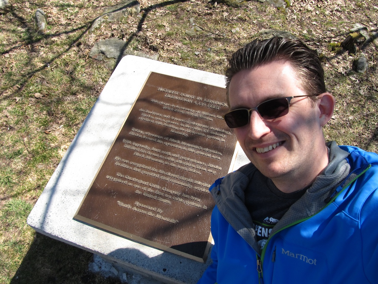
summit, there were a few points of interest though. The obvious one was the actual summit plaque,
which marked the highpoint and gave a short history on the area.
 |
| Summit Plaque and Monument |
 |
| Vanity Shot in front of Summit Plaque |
Additionally, there was a fire tower that was
centrally located on the hilltop.
 |
| Fire Tower at Summit |
 |
| Detail of Fire Tower |
Underneath it, I was able to find a USGS marker with the triangle symbol.
 |
| USGS Marker Beneath Fire Tower |
Strangely, there is some dispute as to whether the highpoint
is indeed underneath the fire tower.
This is said because, nearby, there is a large summit rock with another
USGS marker. That marker is the benchmark marker, and it does have a specific elevation recorded on it.
 |
| Summit Rock |
 |
| USGS Bench Mark with Elevation |
The latter marker apparently sets about 6 feet lower than
the former marker. It could be the true
highpoint if the mound under the tower is manmade. I am not sure which is the true highpoint,
but I made sure to visit both and take vanity shots just to cover my
bases.
 |
| Vanity Shot on Summit Rock |
 |
| Vanity Shot at Fire Tower |
I made a final loop around the summit area and then
descended down the hill back to my car.
I drove down to the entrance and parked by the overlook. This was really the best part. The view was incredible here! It was lunchtime, but I didn’t have the forethought
to bring my lunch here. It would have
been a great spot to spend some time and soak in the beauty. Oh well, if I was going to visit the
highpoint in Tennessee and make it back home all in the same day, I had better
get going…
 |
| View from the Overlook! |
Note before you go:
the highpoint is on private property, so a signed waiver agreement is
needed either on your person or sent in beforehand. A current copy of the agreement can be found
here: