Saturday, September 29, 2012

Highpoint #4: Connecticut


CT Highpoint Marker
Clumsy Vanity Shot


Again I found myself in NYC for a running race, so I decided to take advantage of the opportunity for another highpointing adventure.  Since I went to the NJ highpoint on my last trip, the next closest one was in Connecticut.  I scouted it out on the map, and it looked fairly doable as a day trip being only about three hours drive away from the city.  The trip was on!


Parking Lot Sign
AMC Parking Lot


The Connecticut highpoint is properly the “south slope” of Mt. Frissell, and it is located very close to the geographical point where New York, Connecticut, and Massachusetts all meet (more on that below).  Now, “south slope” is an interesting description.  The thing about highpoints is that they do not always fit the stereotype of being a nice prominent peak visible from a distance.  In the case of Connecticut, it is anything but that.  Indeed, the highpoint marker actually falls on the Connecticut/Massachusetts line, and not on the top of a hill or mountain like one might think.  Indeed, the summit of Mt. Frissell is actually in Massachusetts.  Fortunately, in order to arrive at the highpoint, you do summit a couple of hills along the way if you take the standard route, so the climbing experience is not lost all together. 

I arrived at the trailhead by following East Street on the Massachusetts side and crossing the border into Connecticut where it immediately becomes Mt. Washington Road.  There is a modest parking lot off to the left designated with an “AMC Northwest Parking” sign (see photos above).  I parked here, and just walked back up the road 100 feet or so to the border and made a left into a much smaller parking area.  The trailhead was just beyond there.


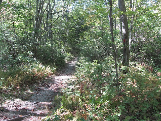
Trailhead (Note the Red Blaze)


The trail itself is pretty well blazed with red blazes, so it is easy to follow in nice weather.  However, with that said, many of the blazes are on low-lying rocks and not on trees, so they could be missed entirely if snow is present.  Fortunately, it was an absolutely beautiful day when I visited, so I could zone out and enjoy the hike. 


"Wall of Rock"

The hike starts off easily enough on a flat graded trail that eventually leads to a “wall of rock”.  There is nothing difficult about the rock; really, it is just straightforward scrambling requiring hands for support at times.  Exposure runs from non-existent to at most a few feet, so there is nothing harrowing here either.  After this wall of rock, there are a few more like it along the way to similarly pass over.  Summiting the intervening hillocks will have you encountering a couple of rock cairns. 


Rock Cairn


The second “summit” has a bit of a clearing where you can go off in 2 different directions.  To the right, a couple of hundred of feet away, there is a summit register hanging from one of the trees with “2,380 feet” etched into the side, designating the elevation.  This is not the official highpoint, but it is the nearest summit, and it is where many people who are highpointing choose to record their accomplishment.   If you return to the clearing and go in the other direction, you eventually will come across another large rock cairn and a small green cylindrical spike emanating from the ground.  It designates the state line and is considered to be the true highpoint.  It is a little underwhelming after all of the scrambling, but it will do. 


Summit Register


If you push on just a little bit farther beyond this point, there is another goodie awaiting the would-be hiker – a tripoint!  They actually have a fairly nice marker (waist high no less) that marks where the three states come together.  MA and NY are etched prominently on the marker.  CT is missing, but someone has tried to mark it in with chalk.  Essentially Connecticut wishes to have nothing to do with this highpointing or tri-pointing business.  So it goes.  


Tri-Point Marker
Vanity Shot at Tri-Point Marker


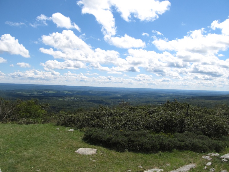
Since there is no prominent peak, there is no grand panoramic view anywhere.  Though, there are some great distant views of the land below along the way.  Just a few feet from the green spike, I found this great view:            


Great View!


Overall, this highpoint was a lot of fun and, refreshingly, was more demanding than all of the other highpoints I have been to up to this point.  I wish I had more time to hike on farther to other scenic destinations nearby.  New England is just a great part of the country to spend time outdoors!  


Saturday, September 15, 2012

Highpoint #3: New Jersey

Standing before the Highpoint in New Jersey


Standing in front of the Official Plaque


On the east coast, it can be difficult to put together a road trip just to visit a single highpoint.  The activity is fun and all, but some of the highpoints are just not that compelling, or they are compelling but not worthy of an all-day drive just to see them.   However, if one has a road trip in the works anyway, then it is a pretty easy matter to tack on a nearby highpoint as an additional stop.  This is exactly what I did on Sunday when I drove to NYC to run the Bronx 10-Miler.  Northwest New Jersey was not all that much out of the way on the drive back to Washington, D.C.  Why not make a slight deviation to visit the highpoint there?  It could not have been easier. 


View of the High Point Monument from a Distance


Detailed View of High Point Monument


New Jersey might be the Garden State, but the state does have some mountains.  The Kittatinny mountain range, a subset of the Appalachian mountains, actually runs through the northwest corner of the state.  The highest peak in this range is called “High Point” and has an elevation of 1,803 feet.  Yes, the highpoint is actually called High Point.  To make it easy to visit, I suppose, High Point is located in High Point State Park and has a road to the top.  


The Steps to the Top, Inside of the Monument

The state park is pretty nice.  It stands out among state parks that I have visited, and, if I lived in the area, I would definitely make regular visits here.  The signage is very good to figure out which turns to make to arrive at the summit.  At one point, you will see a lake and a hill in the distance with a very large obelisk-shaped monument on top of it.  That’s the destination.  The road leads all the way up the hill, culminating in a parking lot just short of the monument.  The parking lot affords great views of the peaceful countryside all around.  The push to the summit, if you will, is just a short paved hill easily walkable in a minute or two (see top photo for a good view of the hill). 


View from the Top of the Monument


The monument itself is most impressive!  Seriously, it rises 220 feet above the natural highpoint for the state.  It’s so high, one has to stand by the parking lot to get a picture in frame with it.  Considering that many state highpoints have little more than a small sign or a tiny geodetic marker, New Jersey is especially impressive in making a mountain out of a molehill.  It is for a good cause though.  The monument was erected in 1930 to commemorate those who have fallen in war.  It is a fitting place for a tribute as it stands prominently and sees many visitors. 

View from the Top of the Monument

One can, of course, enter the monument and even climb to the top.  For the purpose of highpointing, this is an entirely optional exercise.  The goal is simply to reach the “natural” highpoints in each state.  With that said though, it did not seem fitting to come all this way without trying my hand at “climbing” to the top.  The steps go on for quite awhile, but it is possible to get to the top in less than 5 minutes, if you are reasonably fit.  I had just run a race that morning, so I was more than primed.  At the top deck, there are 4 windows looking outwards in each cardinal direction.  Three of them were obscured by condensation, so that really only left one dramatic view to take in.  Fortunately, it was a good one.  This is a pretty part of the country.  It was great to spend some time to enjoy it.  Upon descending, I spent even more time just soaking up the beauty.  This was not an especially difficult highpoint to get to, but it was a rather nice one.  This would be a great one to do on a motorcycle on a beautiful day.  It’s not a bad place to have a picnic either.  Gorgeous views just abound!  


One of the Many Gorgeous Views!


Monday, September 3, 2012

Highpoint #2: Maryland

Maryland's Highpoint:  "Hoye-Crest"


The highpoint in Maryland actually requires a little bit more effort to reach than simply driving up to it like in West Virginia or walking up a hill in a park like Washington, D.C.  Indeed, to reach the highpoint in Maryland, a good 20 minute hike (each way) is involved up a steep trail.  It is not particularly difficult, but it is definitely not as straightforward as stepping out of a car.  Seriously though, the most difficult part about this highpoint for me was actually finding the route.

Road Sign Indicating Path

Yes, if I can find a “wrong” way to do something, I usually will.  Finding the turnoff from the highway for the hiking route was pretty easy.  In fact, there is a pretty large road sign proclaiming “Maryland High Point” with an arrow pointing to the trail.  One can simply park beside the sign in a pull-off strip of the road.  Alternatively, one can proceed to the other side of the road and drive up the JEEP trail to a higher landing which has a parking area. 

Do NOT follow these blazes!
 
My mistake was in parking across the street and just following the red and blue blazes when I reached the other side.  Do not do this!  There is no trail to follow if you do, simply the blazes.  The blazes continue on and on, one hill after the next.  If you pursue them diligently, believing they mark the way to the highpoint, you will arrive at a JEEP on someone’s private property.  What in the world?  I had the opportunity to speak with the property owner, who was actually pretty friendly and let me know where I went wrong.  Apparently, the blazes I was following marked different property lines that were set by a private developer.  To get to the actual highpoint, I needed to proceed down the private road from the property, walk up the main highway (to where I parked), walk up to that higher landing on the JEEP trail, and start my hike from there.  Basically, start all over.  Ugh. 


Rock Cairn Marking the Path
Final Sign Pointing to the Summit

Trail and Red "HP" Blaze

I eventually made it back to my car, and I decided to just drive it up to that higher landing and start anew.  My car sets low, but I still managed to make it to the top of the drivable section without bottoming out.  The road is surprisingly passable in favorable weather conditions.  This put me in a prime position to begin my hike.  The trail to the top is also marked with red blazes, which is a little confusing.  There are other indications along the way as well including rock cairns, red “HP” blazes on some of the trees, trail signs, and a plaque at the summit.  Really, one can’t possibly mess this up, provided they start their adventure here and not below.  So it goes. 


Detail of the Summit Sign
Vanity Shot in front of Sign


Walking to the top was a great deal of fun.  I was kind of in a hurry after all of the lost time from my errant hike, so it was a vigorous push.  The detailed signage was very reassuring, and, soon enough, I saw the final sign pointing to “Backbone Mtn MD Highpoint”.  Walking over to the true summit, I was met with a huge rock cairn and a very large posted sign indicating that “Hoye-Crest” was the true highpoint of Maryland coming in at 3360 feet.

Honorary Certificate

The view is somewhat blocked from the summit, so it is not the most scenic of highpoints.  However, it is a fun one to get to.  Be sure not to miss the mailbox next to the cairn.  I nearly did.  Inside, there is a sign-in book and a bag of certificates.  Yes, you can claim a certificate for making it to the top – not a bad deal!  The only drawback is that the position of the sign makes it nearly impossible to take a photo of oneself in front of the sign.  That took a few practice shots just to get a passable photo.  Oh well.  Not a big deal.  I am just glad I did not miss out on making it to the highpoint all together.  


View from the Summit


Highpoint #1: West Virginia

Sign Proclaiming Highpoint of West Virginia


With the highpoint in Washington D.C. squared away, I was eager to set out on a road trip and go after a genuine state highpoint.  Geographically, D.C. is located within a few hours drive of no less than 4 highpoints (DE, WV, MD, and PA).  Calculating the distances, I settled on a combo trip that would include the highpoints of WV and MD in the same day.  This is a pretty reasonable duo, in fact, since one has to park in WV to reach the highpoint in MD, but more on that in separate blog post. 

Observation Tower

The highpoint of West Virginia is Spruce Knob, which comes in at an impressive (for the east) 4,863 feet.  It is located in a very scenic area of the state, just down the road from the famous Seneca Rocks, a popular retreat for rock climbers.  It is a fortunate fact that Spruce Knob is at a higher elevation than the Seneca Rocks since the latter’s peak is only accessible by technical rock climbing.  Indeed, Spruce Knob is at the other end of the spectrum in terms of difficulty.  To reach the summit, you can simply drive your car to the top.  It’s a family friendly destination, in that regard. 

View from the top of the Observation Tower

The road to the top is a very windy and steep affair extending for several miles, but the views from the top are well worth the effort.  The road culminates in a parking lot, and there is a sign nearby proclaiming the highest point.  There is a man-made observation tower that lies 900 feet beyond the sign, further uphill.  Along the way though, be sure not to miss the actual USGS marker for the highpoint, which is inconspicuously placed in the ground.  The stone tower is fairly large and has two levels.  The upper level boasts a beautiful panoramic view of mountains all around.  The view is striking in every direction!  It really is a gorgeous place to be, and one does not have to work very hard to get there.  Better yet, at the base of the observation tower, there is a sign for the “Whispering Spruce Trail” which allows you to hike a very short loop back to parking lot.  It is a very easy, well-graded path that commands impressive views at every turn. 


USGS Marker

Overall, Spruce Knob was a lot of fun to visit.  The only advice I would give to the would-be goer is to print out the directions in advance.  There were large swaths of West Virginia where I could not get a cell phone signal, so any last minute routing with the phone’s GPS may very well not be a possibility.  

Whispering Spruce Trail
View of the Trail

View along the Trail