 |
| Touching The Highpoint! |
 |
| Vanity Shot at Highpoint Sign |
Yay, my home state! I
am embarrassed to admit that I grew up less than 90 minutes from the highpoint
in Pennsylvania, and I have never been there.
It was something I was only vaguely aware of, really. If I had to reflect on it for a minute or
two, I would probably have summoned the name Mt. Davis as being the highest
mountain in Pennsylvania, but I knew nothing about it. I certainly would never have thought to seek
it out as a destination either, but that ended up being my loss. This was a very nice part of Pennsylvania to
visit, and I managed to catch it during the seasonal change of the leaves.
 |
| Observation Tower |
 |
| Sign at Entrance |
 |
| A Clear Road Sign North of the Entrance |
The drive there from DC was anything but clear though. The route quickly devolves into farm roads
and tiny offshoots from farm roads that are gravelly. The GPS on my phone guided me to the
highpoint well enough, but I might be reluctant about the drive in severely
inclement weather. There were certainly
no signs on this approach indicating that a highpoint might be nearby. Ironically though, when I left on the north
side, there was a very large road sign calling out the highpoint. So how you arrive here really makes a
difference.
 |
| Relief Map at Top of the Tower |
 |
| The View from the Top of the Tower |
I was able to pull into a parking lot just below the
highpoint tower. So the climb to the
summit was a very short walk up a moderately sloping paved path. I did the obligatory photo shot at the
signpost along the way. The observation
tower is fairly simple in design, and after 7 quick flights of steps, you will
find yourself at the top. The platform
is small and narrow, but the panoramic view is grand. I was able to see the full fall foliage well
into the distance. On the platform
itself, they had a 3D relief map of the surrounding area and a short paragraph
in raised lettering above it discussing the highpoint.
 |
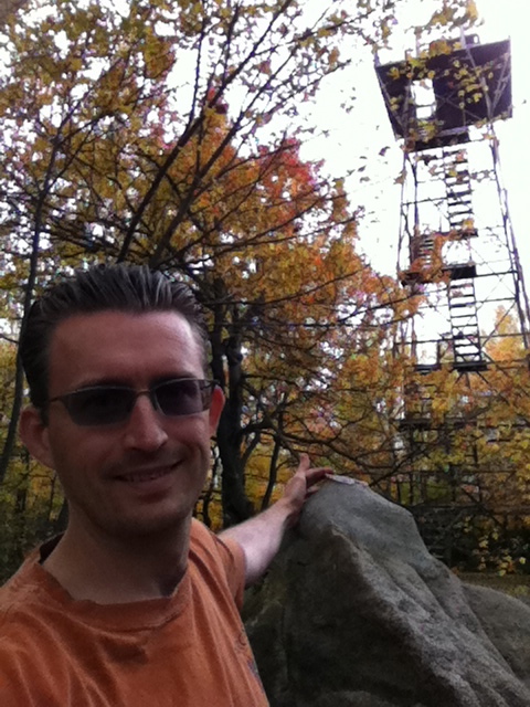
| Looking Straight Down |
Of course, the tower is man-made so climbing to the top of
it is entirely unnecessary. The true
highpoint is actually nearby much closer to the ground. Indeed, just beyond the tower there are some
large boulders. The largest among them,
coming in at shoulder height or so, has a geodetic marker on the top of
it. That’s the highpoint! I posed for a self-taken photo of me touching
the highpoint with the observation tower in the background (see below). The marker has no sign pointing it out, and
it is very easy to miss! I imagine most
of the visitors here climb the tower and completely miss the marker. It is an openly hidden secret, really.
 |
| The Highpoint is on the Largest Rock Straight Ahead |
Just beyond the tower and the boulders, there is an
extensive series of signs, arranged side by side, talking about the surrounding
area and points of interest: the tar
kiln, the Baughman rocks, etc. One of the
signs interestingly points out how the sorted stone pattern at and around the
highpoint was entirely due to frost pressure.
That was kind of cool. Beyond
this, there is a very short trail that leads down to a picnic area and another
parking lot. I suppose one could have
started there and properly summited via this trail, but it all comes down to
which way you are traveling.
 |
| The Highpoint Marker |
One thing I definitely recommend is traveling down the road
from the highpoint a quarter mile or so.
There is a small pull-off there with a very lovely view of “Highpoint
Lake” off in the distance. The views are
gorgeous here, making this a fun highpoint to do.
 |
| View of Highpoint Lake |


No comments:
Post a Comment