 |
| Atop Mt. Mansfield -- Finally! |
With summer fast approaching, I was itching to get on the
road again. I strategically waited until
the weekend AFTER Memorial day weekend, so I could avoid the traffic and
crowds. My first stop? Vermont.
I had some unsettled business up there, and I was all too keen to
resolve matters.
See, back in February when I did my highpointing trip for
Rhode Island and Massachusetts, I also tried my hand at Vermont. Yes, February, right after the Nemo storm
passed through the area. There really
could not have been more snow on the Mt. Mansfield when I visited then (what
was I thinking?). It ultimately did me in
when I approached the final headwall, forcing me to come back another time if I
ever wanted to lay claim to the summit.
Well, last Friday was the day!
There wouldn’t be any snowdrifts to swallow me up this time around. The challenge was on!
I left my place in D.C. first thing in the morning, and I
ultimately made it to the Stowe ski resort in upstate Vermont late in the
afternoon. I wanted to take the exact
same route that I did in February, so I could see how close I really got to the
summit and figure out where I went wrong.
So, for me, that meant taking the Long Trail south and connecting to the
Profanity trail, which is a recommended approach in prime winter, when it’s
passable anyway.
 |
| Road: Summer |
 |
| Road: Winter |
I parked in the small hiker’s lot next to the gate just off
the road from the uphill entrance to the ski resort and well before Smuggler’s
notch. The first difference that I
noticed was that the gate was open and the road was pristine. In the winter, that gate is as far as you can
get by car as they close the rest of the road until late spring.
 |
| Trailhead: Winter |
 |
| Trailhead: Summer |
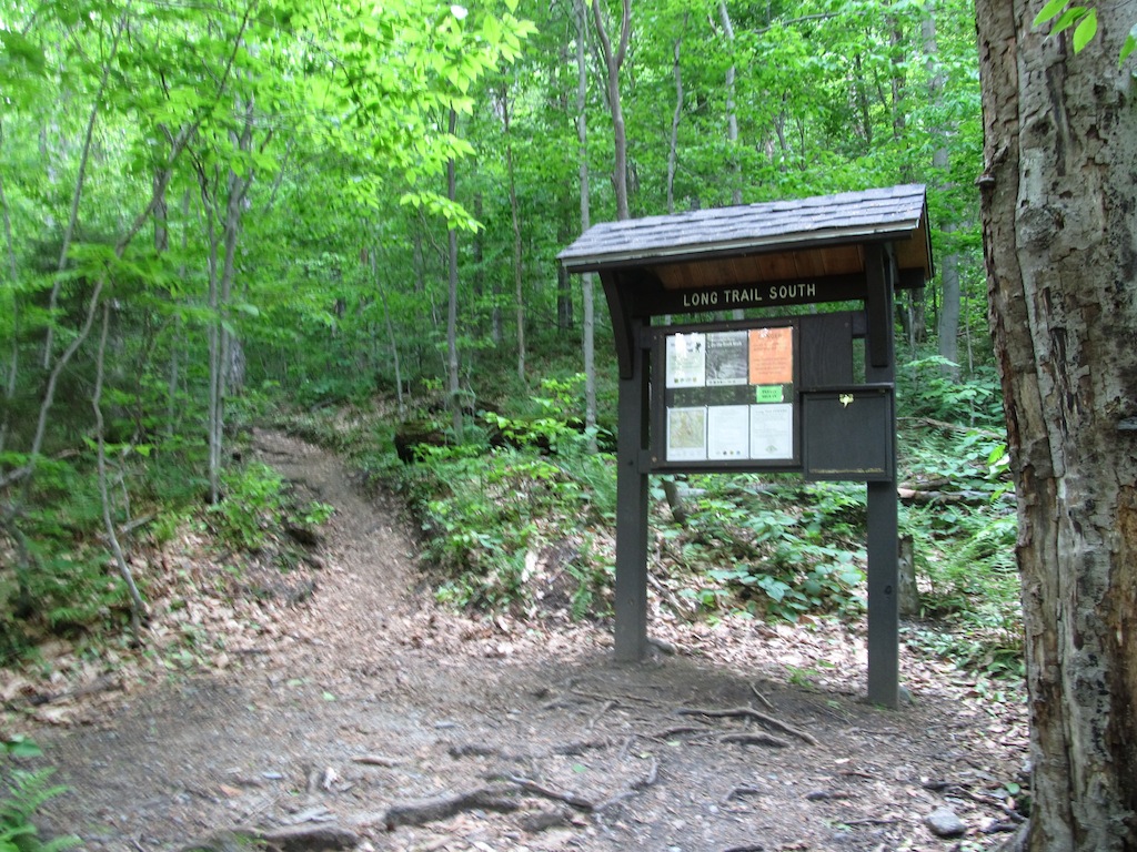
After a little bit of a walk, I crossed over the road into
the woods at the trailhead for Long Trail South. From there, it is a 1.7 mile hike all uphill
to the Taft Lodge. In the winter, the
route was a very popular one with backcountry skiers and the occasional person
on snowshoes, like me. There are plenty
of switchbacks, interrupted by a few stream crossings. In the snow, there was a very clear, smooth
path made by skiers in the prior days. I
was able to snowshoe right along that path with no problem at all. I, thankfully, had heel lifts on my snowshoes
which helped with the elevation gain considerably. In summer though, the path was definitely
very rocky and not so smooth. There were
plenty of tiny obstacles to be negotiated, but it was still a pretty
straightforward hike.
 |
| It's Easier to Snowshoe... |
 |
| ...Than it is to Hike! |
In the winter, the route went direct to the Taft Lodge! Evidently, skiers are pretty efficient at
getting where they need to go. In the
summer, the path meandered and came back around to it, making for a gentler
approach.
 |
| Taft Lodge: Winter |
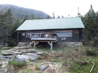 |
| Taft Lodge: Summer |
On both hikes, I opted for the Profanity Trail to go
straight up the mountain with less danger of rockfall and exposure. Look at the signs though from the two
trips! This really tells you how much
snow they get here in the winter!! The
smaller sign underneath the main sign was completely covered by snow; I didn’t
know it existed!
 |
| Sign for Profanity Trail: Winter |
 |
| Sign for Profanity Trail: Summer |
Going up from here was definitely tricky in the winter. I think most of the skiers just stop at the
lodge and either take the moguls down for some good backcountry skiing, or they
just wander over to the Chin Clip run at the ski resort and ski down the black
diamond route. Why do I say this? Because routefinding became quite a bit more
difficult after I passed the lodge. The
Profanity Trail is marked with blue blazes, but it seems a little harder to
follow, at least initially.
 |
| Profanity Trail, Earlier On |
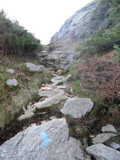 |
| Profanity Trail, Near the End |
Last time, I made my own path, and proceeded up the mountain
the best I could, but I had enormous difficulty. Every once in awhile, I would just fall into
a snowdrift up to my stomach, and sometimes up to my neck! These were, I later learned, called “spruce
traps”. They can be kind of dangerous,
especially if you are climbing solo. I
eventually had to pull out the ice ax.
With two hands, I plunged it horizontally in front of me, and pulled
myself farther up the mountain, again and again. It was intense. Ultimately, I reached a spot a bit in front
of the headwall that I could not get past.
Everything I tried with my snowshoes, ice ax, grabbing a random spruce
branch, or finding an alternative route just failed. I was stuck!
I eventually had to accept that I was not going to get the summit, and
resolved to return another day.
 |
| DEEP Snow!! |
 |
| To be Continued Another Day! |
Well, this time, the story was much better. The Profanity Trail is MUCH easier to follow
when there is no snow. It also goes a
bit to the left of where I was climbing in February. I clearly was off-route, and when I looked
over to it in the summer, I was surprised I could get through any of it at
all. The snow hides a lot! No, this time the path was narrow and filled
with straightforward scrambling. It did
not take long for me to reach the alpine zone.
 |
| Yay! The Difficult Portion is Over! |
From there it is a piece of cake to finish. Just follow the boarded off trail portion to
the true summit.
 |
| It's Pretty Easy Going From Here to the Summit! |
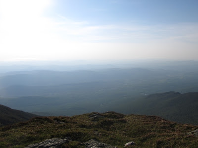
At the top, the view is incredible. A 360-degree panoramic field of vision is
available to you, allowing for a keen view of Stowe ski valley and points
beyond. I was the last hiker of the day
there, so I had the whole place to myself.
It was so beautiful. I took my
usual photos.
 |
| View of Stowe from the Summit |
There was a USGS marker to
denote the summit, but it looks like it was kind of beat up. I eventually decided to head down, before
the sun beat me to it.
 |
| Vanity Shot at Summit USGS Marker |
 |
| Detail of Beat Up USGS Marker at Summit |
I made great time back to the Taft Lodge, but now it was
starting to get dusk. I was like, “oh I
am pretty close to the car now; Just smooth sailing from here.” Ugh.
Sure enough, I messed up on one of the stream crossings, and kept
following the stream instead of the trail.
Rapid current, wet rocks, and darkness made for a treacherous
combination. I kept descending, trying
to lose elevation, but there was no sign of the Long Trail or the highway that
I walked in on. Luckily I had a headlamp
and GPS, but still this was quickly becoming bad by the minute. I tried wandering away from the ravine, but
it was dense and not yielding me anything useful. After a good half hour of this, I finally
stumbled onto a clearing next to the rapid.
Sure enough, it put me right back on the Long Trail. I couldn’t believe it!! I signed out at the
trailhead, and walked back to my car.
It’s funny because I also had trouble following the trail back
in February on the way down. I got lost
in the moguls and eventually made my way over to Chin Clip and walked down the
ski run to the Stowe parking lot. I am
sure ski patrol loved the idea of a guy emerging from the woods onto one of
their ski runs holding an ice ax in his hands.
Oh well, so it goes in this highpointing business. The skiers could not have been friendlier
though, with one going so far as to cheer me on.
 |
| View of Mt. Mansfield, by way of Chin Clip, from Stowe Ski Resort Parking Lot |
In truth, this mountain was just not going to give up its
highpoint easily to me. I never had so
many problems before with such a seemingly simple hike. Oh well, it’s off the list, and I could not
be happier. Honestly though, this is a
beautiful hike anytime of the year. I am
glad it turned me on to a pretty cool ski resort too.
Are there other ways up the mountain? Yes, several of varying difficulty. There is even an auto road that goes up to
the lower summit in the summer, but you still have to hike a nontrivial
distance from there to the true highpoint, so it’s not exactly a drive-up. It also feels like cheating, since it is a
private (read: expensive toll road) road
up the mountain. There is also a gondola
available at the ski resort, but I am not privy to the details. Good luck though on any approach; you likely
will not be disappointed. Just be
careful coming down. Complacency can
lead to adventure rather quickly.
 |
| Beautiful Parting Shot from the Summit |


No comments:
Post a Comment